Property Record
170 Scott Rd, Eatonton, GA 31024
NEARBY LISTINGS FOR SALE OR LEASE
Property Detail
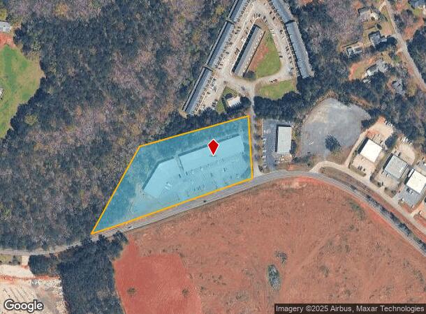
170 Scott Rd
102-001002
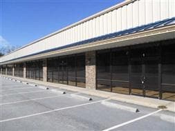
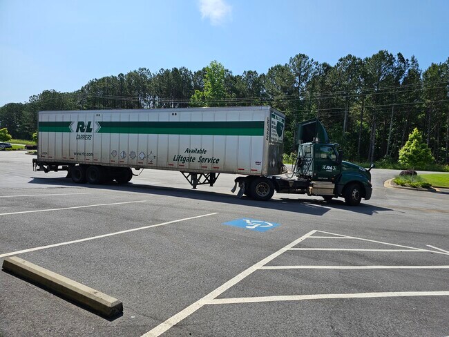
Scott Rd Commercial
Stripcommercialcenter
PARCELS 2, 3, 4 AND 5 COMBINED
X
Putnam
13211C0350B
Georgia
2024
2
2025
3.76 AC
960103
Georgia Northeast
21,000 SF
Other Market Areas
DEMOGRAPHICS near 170 Scott Rd
1 Mile
3 Mile
5 Mile
2024 Total Population
546
5,574
14,304
2029 Population
620
6,450
16,752
Pop Growth 2024-2029
+ 13.55%
+ 15.72%
+ 17.11%
Average Age
50
51
52
2024 Total Households
245
2,523
6,381
HH Growth 2024-2029
+ 14.29%
+ 15.81%
+ 16.96%
Median Household Inc
$81,250
$83,012
$95,005
Avg Household Size
2.20
2.20
2.20
2024 Avg HH Vehicles
2.00
2.00
2.00
Median Home Value
$266,417
$384,985
$472,277
Median Year Built
1999
2003
2004
Nearby Places
Map Layers
Map Styles
 Street
 Aerial
- Restaurants
- Banks
- Shops
- Fitness
- Groceries
SALE & LEASE HISTORY
LISTING DATE
SALE/LEASE

May 09, 2024
For Lease
Apr 22, 2022
For Lease
Nearby Properties
Address
Land Use
TOTAL SIZE
Lot Size
Zoning
Address
Land Use
TOTAL SIZE
Lot Size
Zoning
122,249 SF
12.50 AC
Address
Land Use
TOTAL SIZE
Lot Size
Zoning
5.07 AC
Address
Land Use
TOTAL SIZE
Lot Size
Zoning
4,500 SF
9.13 AC
C-1
Address
Land Use
TOTAL SIZE
Lot Size
Zoning
18,828 SF
14.89 AC
COMMERCIAL
Address
Land Use
TOTAL SIZE
Lot Size
Zoning
66,844 SF
9.35 AC
Address
Land Use
TOTAL SIZE
Lot Size
Zoning
1,444 SF
3.96 AC
RM-3
Address
Land Use
TOTAL SIZE
Lot Size
Zoning
10,776 SF
3.36 AC
C-1
Address
Land Use
TOTAL SIZE
Lot Size
Zoning
18,121 SF
17.45 AC
C-1
Address
Land Use
TOTAL SIZE
Lot Size
Zoning
9,368 SF
8.29 AC
C-1
Address
Land Use
TOTAL SIZE
Lot Size
Zoning
24,215 SF
3.81 AC
C-2
Address
Land Use
TOTAL SIZE
Lot Size
Zoning
12,564 SF
10 AC
R-1
Address
Land Use
TOTAL SIZE
Lot Size
Zoning
2,300 SF
7.56 AC
C-2
Address
Land Use
TOTAL SIZE
Lot Size
Zoning
380.93 AC
Address
Land Use
TOTAL SIZE
Lot Size
Zoning
41,510 SF
2.95 AC
C-1
Address
Land Use
TOTAL SIZE
Lot Size
Zoning
11,245 SF
1.77 AC
Address
Land Use
TOTAL SIZE
Lot Size
Zoning
227.44 AC
Address
Land Use
TOTAL SIZE
Lot Size
Zoning
28,044 SF
2.85 AC
Address
Land Use
TOTAL SIZE
Lot Size
Zoning
16,000 SF
4.89 AC
C-1
Address
Land Use
TOTAL SIZE
Lot Size
Zoning
37,170 SF
2.70 AC
C-1
Address
Land Use
TOTAL SIZE
Lot Size
Zoning
24,060 SF
3.20 AC
C-2
Address
Land Use
TOTAL SIZE
Lot Size
Zoning
22,800 SF
3.88 AC
C-2
Address
Land Use
TOTAL SIZE
Lot Size
Zoning
197.37 AC
Address
Land Use
TOTAL SIZE
Lot Size
Zoning
7,286 SF
0.51 AC
RM-3
Address
Land Use
TOTAL SIZE
Lot Size
Zoning
9,375 SF
8.84 AC
I-M
Address
Land Use
TOTAL SIZE
Lot Size
Zoning
261.03 AC
Address
Land Use
TOTAL SIZE
Lot Size
Zoning
6,196 SF
3.96 AC
Address
Land Use
TOTAL SIZE
Lot Size
Zoning
3,000 SF
1.61 AC
C-2
Address
Land Use
TOTAL SIZE
Lot Size
Zoning
16,000 SF
1.75 AC
C-2
Address
Land Use
TOTAL SIZE
Lot Size
Zoning
41,395 SF
6.43 AC
RM-1
Address
Land Use
TOTAL SIZE
Lot Size
Zoning
20,374 SF
2.03 AC
C-1
The World's #1 Commercial Real Estate Marketplace
Connect with us
© 2025 CoStar Group
The information above has been obtained from sources believed reliable. While we do not doubt its accuracy we have not verified it and make no guarantee, warranty or representation about it. It is your responsibility to independently confirm its accuracy and completeness. Any projections, opinions, assumptions, or estimates used are for example only and do not represent the current or future performance of the property. The value of this transaction to you depends on tax and other factors which should be evaluated by your tax, financial, and legal advisors. You and your advisors should conduct a careful, independent investigation of the property to determine to your satisfaction the suitability of the property for your needs.